Argentina Expedition
Exploring
Northern Argentina
20180211-0308
Final Update:
20180307Back to Bill Caid's Home Page.
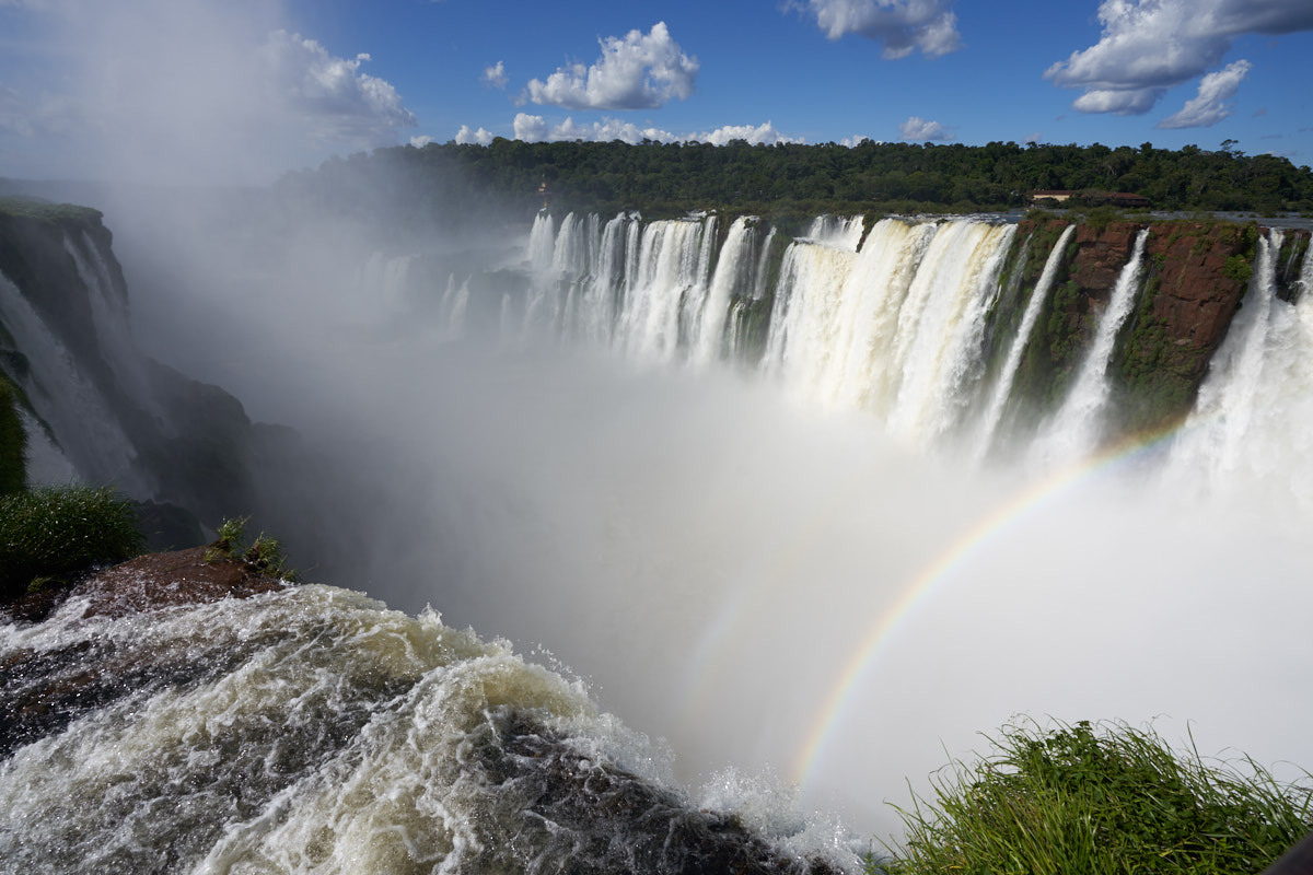
The Devil's Throat at Iguazu Falls.
Sony A7RM3: 1/500 sec, ISO 100, 16mm at f/8
All photos copyright, Bill Caid 2018. All rights reserved.
The Trip
Argentina, and other South American countries,
have been on "our list" for some years. We traveled to
Brazil many years ago and had a great time. This time,
our plan was to
visit Argentina and explore the northern part of the
country. Our original idea was to fly into Buenos Aires and get
a rental car and drive around. But, Argentina
is a very large country and the distances between cities are substantial so we concluded
that the driving
time would become a factor. So, we elected to
fly for the long-distance legs of the journey and use
a rental car
to explore the close countryside. Our final
plan was to fly into
Buenos Aires and then immediately fly to Iguazu
Falls at the triple border of Argentina, Brazil
and Paraguay. We planned to stay
several days at Iguazu Falls and then fly to
Cordoba to get our rental car. From
Cordoba, we would head toward Mendoza and
then north along the foothills of the Andes
Mountains to Salta. The
Cordoba-Mendoza-Salta triangle has a number
of national parks and plenty of
good things to see and do,
but distances are substantial so
planning is required. We
will return the rental car in Salta
and fly to Buenos Aires to check out
the city for a few days
before heading home.
For this trip, the bulk of the photos were shot with my new Sony A7RM3 with either a fully manual 35mm Voightlander, automatic Sony 24-70 f/2.8, or automatic Sony 16-35mm f/2.8 lens. Kathleen brought her FujiFilm XPro-2 camera with 16-55mm lens.
We usually travel with a GPS transponder, our SPOT, to allow our friends to keep track of us should things "go south". As noted above, a previous trip and "gone south" and nobody knew where we were. The SPOT allows us to have a record of our path and overlay it on either maps or satellite images. Both are below. It should be noted that the SPOT reporting is an "open loop" protocol with no guaranteed delivery of location. As such, it will miss some positions, thus explaining the missing updates. Typically, the misses are associated with being in high-walled canyons or other areas that impeded a clear path to the satellite. The star icon represents an intentional "OK" message that must be triggered by a combination of buttons on the SPOT device.
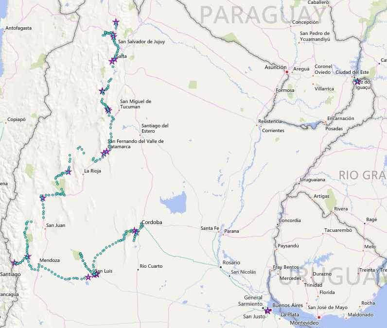
Our SPOT logs overlaid on a road map of northern Argentina. Note there are reports shown as star icons from Buenos Aires in the lower right corner and from Iguazu in the upper right corner.
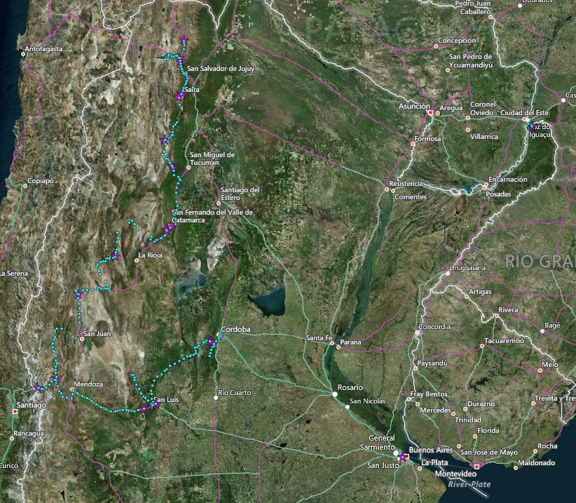
Our path overlaid on a satellite image. Note that the western part of the country is in the foothills of the Andes mountains and is very rugged. The eastern portion of the country is relatively flat farm land.
Tracking Our Location Via The SPOT
Some years ago, after a scary mechanical failure in the canyons and mesas of southern Utah, we decided that we need a better way to advertise our position and call for assistance if needed. Kathleen found out about the SPOT which is a GPS locator that transmits your coordinates via satellite so that others can see your location. The location is plotted on Google maps and a "bread crumb" feature is available for an additional fee. We have the enhanced service, so you can see our historical path back 50 updates or so. See our current location plotted on Google Maps in Real-Time via SPOT satellite geo-locator device. This page is "book-markable" and is updated approximately every 15 minutes, but may miss updates due to inability of our transmitter to reach the satellite. The communication is "open loop" so the device never knows if it's messages are actually going anywhere, it just keeps trying until the next update is available. If we are in a congested urban area with high buildings (like Manhattan) or in deep canyons, the position may not update. We try to send an "OK" message once a day just to let everyone know that we are, in fact, OK. Given that this is a remote area and has many obstacles (like mountains), it is not clear how well this capability will perform.Connecting and Contacting Us While on the Trip
Because of internet connectivity issues on a previous trip, we purchased a MiFi cell phone modem that allows us to connect nearly anywhere there is at least 3G service via cell phone (which is most of the cell phone service area available today). But, as we all know, cell phones are useful many places, but not everywhere has coverage, particularly in the remote areas of the country and outlying territories. Our phones and the modem are enabled daily so you may contact us, although it may take a few days for us to respond. But, we will respond. My email, spelled out, is "bcaid at yahoo dot com".Photographic Hardware
For this trip, the bulk of the photos were shot with my new Sony A7RM3 with either a fully manual 35mm Voightlander, automatic Sony 24-70 f/2.8, or automatic Sony 16-35mm f/2.8 lens. Kathleen brought her FujiFilm XPro-2 camera with 16-55mm lens.
GPS Path Logs
We usually travel with a GPS transponder, our SPOT, to allow our friends to keep track of us should things "go south". As noted above, a previous trip and "gone south" and nobody knew where we were. The SPOT allows us to have a record of our path and overlay it on either maps or satellite images. Both are below. It should be noted that the SPOT reporting is an "open loop" protocol with no guaranteed delivery of location. As such, it will miss some positions, thus explaining the missing updates. Typically, the misses are associated with being in high-walled canyons or other areas that impeded a clear path to the satellite. The star icon represents an intentional "OK" message that must be triggered by a combination of buttons on the SPOT device.
Our SPOT logs overlaid on a road map of northern Argentina. Note there are reports shown as star icons from Buenos Aires in the lower right corner and from Iguazu in the upper right corner.
Our path overlaid on a satellite image. Note that the western part of the country is in the foothills of the Andes mountains and is very rugged. The eastern portion of the country is relatively flat farm land.
Trip Details
The link
table below contains links to the photos and dialog for each
of the days of the expedition.
| Part | Dates | Adventure Locations |
|---|---|---|
|
1
|
20180211-13
|
San Diego to Iguazu Falls,
Argentina
|
| 2 |
20180214 |
Iguazu Falls
Boat Trip |
| 3 |
20180215 |
Cordoba,
Argentina |
| 4 |
20180216-17 |
Alta Gracia and
Villa General Belgrano, Argentina |
| 5 |
20180218 |
Alta Gracia to
San Luis, Argentina |
| 6 |
20180219 |
Sierra de las
Quijadas |
| 7 |
20180220-21 |
Mendoza and
Aconcagua (Part 1) |
| 8 |
20180220-21 |
Mendoza and
Aconcagua (Part 2) |
| 9 |
20180222 | Uspallata to San
Jose de Jachal |
| 10 |
20180223 |
San Jose de
Jachal to Nonogasta, Argentina |
| 11 |
20180224 |
Nonogasta to
Chilecito, Argentina |
| 12 |
20180225 |
Catamarca to
Tafi, Argentina |
| 13 |
20180226 |
Tafi del Valle
to Cafayete, Argentina |
| 14 |
20180227 |
Quebrada de
las Conchas (Part 1) |
| 15 |
20180227 |
Quebrada de
las Conchas (Part 2) |
| 16 |
20180228 |
Salta to
Humahuaca |
| 17 |
20180301 |
Humahuaca to
San Antonio de las Cobres |
| 18 |
20180302-03 |
Purmamarca to
Salta and Salta Walk-About |
| 19 |
20180304-05 |
Recoleta
Cemetery |
| 20 |
20180306 |
Casa Rosada
and Catedral Nacional |
| 21 |
20180306 |
Teatro Colon |
Conclusions and
Advice to Travelers
Foreign travel
requires a substantial amount of pre-planning and
preparation. When you go, be sure to check the State
Department's web site for travel advisories, visa requirements
and any vaccinations that may be required for your chosen
destination. Notify your bank in advance of your trip
lest you stand the chance of the credit card being disabled or
flagged as stolen. Sometimes, with luck, reasonably
priced plane tickets can be obtained if the seats are booked
sufficiently in advance. Verify that your passport is
valid, not due to expire during your travel and has at least
one free page available for entry and exit stamps.
Requirements vary by destination countries, so forewarned is
forearmed.Yellow Fever is transmitted by mosquitoes and is enjoying a resurgence in the northern part of the country. Check about vaccination requirements before you travel. We encountered signs and warnings in the area near Iquazu, but nowhere else.
Argentina has had multiple currency crashes over its history, each one producing devastating effects on the welfare and confidence of the average citizen. The effects of these past crashes (the last on in the 2000's) is readily apparent today. ATM machines are pervasive and easy to find. Finding cash in them, however is hit-and-miss. Withdraws are limited to 2000 pesos per transaction and it comes with a hefty 6% fee (a bank tax, if you will). Machines are not restocked frequently, thus allowing the banks to hold on to more of the citizen's cash for longer and preventing a potential run on the bank(s). We had no trouble using our card at these machines, that is to say the network recognized us and allowed access. Gaining actual access to cash was another thing altogether. Banks have the population by the balls, they fully control who gets what and when they get it. I believe that the restocking schedule for these machines is intentionally infrequent to assert this control. The mostly rural areas will require cash for purchases, so you must have some cash available. Given the history of currency instability, American dollars are not only accepted everywhere, but are preferred. I always travel with a big wad of dollars "just in case", but these were expended in just a few days requiring daily withdrawals from the ATMs. Credit cards are accepted in the cities at the better establishments, but you cannot count on that in every location. Frequently, tips must be paid in cash, so proceed accordingly. Ditto for taxis.
I found the food to be, particularly beef, to be great. That said, you really need to like beef to eat here as it is the primary protein. We both found the food to be bland as the use of spices is rare. And, when spices are used, it is typically only salt. If you are a food bigot, bring your own spices as you will not find them here. Simple black pepper is nowhere to be found.
Back to Bill Caid's Home Page.
Photos and Text Copyright Bill Caid 2018, all rights
reserved.
For your enjoyment only, not for commercial use.